Corridor Mapping
Corridor mapping is used for the planning, mapping and monitoring of constructions such as railway lines, dykes, overhead power lines, pipelines and/or roads. In such projects, image data are usually expected in addition to laser data. Moreover, video cameras pointing in different directions can be used as an option.
Corridor mapping projects are typically performed with helicopters. The advantage of helicopters over aircraft is their mobility, which makes it much easier for them to closely follow the corridor course. Also, helicopters can fly slower and at lower altitudes.
Data gathered from helicopter survey flights are characterized by a higher point density and higher image resolutions.
Monitoring of power line
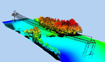
color-coded elevation model with point-cloud
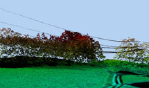
orthophoto with point-cloud
Train line
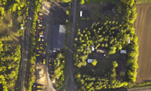
RGB aerial image with 5 cm resolution
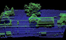
classified point cloud (ground points and other points)